A few days before Christmas I met up with my friends Andrew Simons and Phil Crumpton to design a tour of
Black Patch Park. They, I and others have campaigned to save and restore this park for over ten years. A mix of protest, with lobbying by letter and meetings - plus the economic crisis - saved the place from ill-judged plans to designate this small green space for industrial building. This was from the first
Wikipedia piece I wrote
about the park in 2006.
![]()
Black Patch Park and the adjoining Merry Hill allotments are 2.5 miles north-west of the centre of Birmingham on the Sandwell side of the city boundary, surrounded north, east and south by railway embankments. One of these carries the West Coast main line that with the A41 and Birmingham Mainline canal are the arteries, old and new, of what is now known as the city’s 'North West Corridor of Regeneration'. In the centre of Black Patch Park, Boundary Brook, which for centuries marked the boundary between Staffordshire and Warwickshire, meets Hockley Brook, which once separated the country towns of Handsworth and Smethwick.
Black Patch is a green pentagonal edged by Foundry Lane to the west and south, Woodburn Road to the north, and Perrott Street and Kitchener Street to the east beyond which, as far as Handsworth New Road, stretches the fertile triangle of Merry Hill Allotments.
Lying amid intersections, boundaries and important routes, Black Patch Park’s twenty plus acres have a special aura. Sometimes this place can be sunny and convivial, at others times, shaded, misty – especially at first light – and a little eerie; one moment a serene and peaceful place full of birdsong and the sound of breeze in the trees, another moment full of human activity and passing trains seemingly on every side.
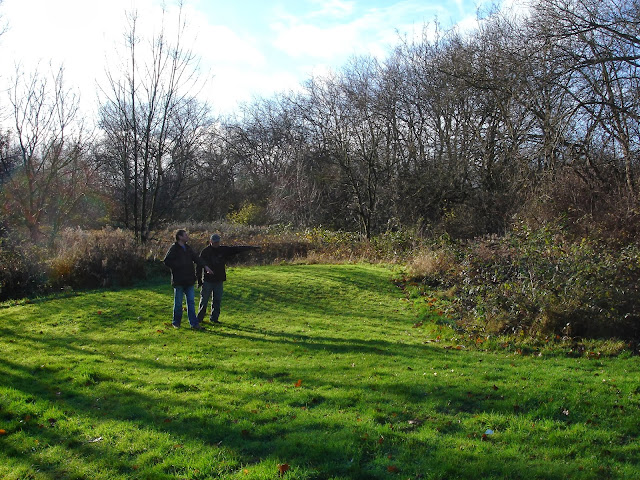
Of course revisions removed all those unreferenced 'opinions' - quite rightly. Phil and Andrew met me near the bridge where I followed them with pencil and notebook as we discussed suitable places to stop and talk about an aspect of the park...
![]() |
| Philip and Andrew by the bridge at the junction of Boundary and Hockley Brooks - 22 Dec 2013 |
A WALK AROUND THE BLACK PATCH (first draft)
Notes prepared by Simon Baddeley, Phil Crumpton and Andrew Simon - for the Friends of Black Patch Park on a meeting in the park on Sunday 22 December 2013 to plan a visitors’ tour of the park
1.
“Where we stand”,
52° 29.899', -1° 56.650' The bridge. Our tour starts at the ancient boundaries of Anglo-Saxon lands, where two streams meet, Hockley Brook and Boundary Brook. Bridged now; once a ford.
![]() |
| The Black Country 'The earth seems to have been turned inside out. Its entrails are strewn about; nearly the entire surface of the ground is covered with cinder heaps and mounds of scoriae. The coal which has been drawn from below ground is blazing on the surface. The district is crowded with iron furnaces, puddling furnaces, and coal-pit engine furnaces. By day and by night the country is glowing with fire, and the smoke of the ironworks hovers over it. There is a rumbling and clanking of iron forges and rolling mills. Workmen covered with smut, and with fierce white eyes, are seen moving about amongst the glowing iron and the dull thud of forge-hammers.
Amidst these flaming, smoky, clanging works, I beheld the remains of what had once been happy farmhouses, now ruined and deserted.' |
![]() |
| Boundary Brook in summer |
2. Black Patch and the Gypsies,
52° 29.950', -1° 56.673' On the rough path into the park just off Woodburn Road and opposite Anne Road. Here we speak of the Industrial terrain of the Black Country – high undulating banks of slag, foundry waste. Detritus and oily trickling waterways – and learn about the Gypsies with Black Patch Park and how they were violently evicted from here in order to found Black Patch Park in 1910.
![]() |
| We chat with Michelle and Bridget and families on the Black Patch in June 2011 |
The story, as told by
Ted Rudge, of Queen Henty and her husband. Her curse on anyone who builds on the Black Patch. (
Her ghost - scroll down this 2011 blog entry to read an account)
![]() |
| Queen Henty |
3.
From a place to a limbo,52° 29.929', -1° 56.821' Standing on the pavement next to the park just where the Hockley Brook passes under Woodburn Road. What was once a ‘place’ before the industrial revolution and continued as a space between factories for dumping waste and as a Gypsy settlement has, post-industrialisation, become almost a non-place, its surrounding factories mostly derelict and the surrounding population, once its users, decanted from the area. This is the challenge for the future of the Black Patch, on the boundary of two local councils, to be better recognised as a stewarded public space.
![]() |
| Woodburn Road ~ limbo |
4.
The Old Main Entrance to the Black Patch,
52° 29.916', -1° 56.848' From a position just inside a corner of the park where Woodburn Road meets a bend in Foundry Road. An avenue of mature London Plane trees runs south-east against a background of Grey Poplars lining the Boundary Brook on the other side of the main playing field. This is one of the finest views of a typical late Victorian Park, snowy black and white in winter; a feast of greenery in summer.
5.
The Coppice,
52° 29.811', -1° 56.726' Having strolled down the SE avenue, we stop where the path divides, to meet an exit into Foundry Lane just before the Soho Triangle of the old LNW Railway or north east along the edge of Boundary Brook. This was a confluence of local population, industrial buildings and parkland; the park ill-tended; the population dispersed; the industry departed. There are views to be restored, easy to see with a selective cutback of shrubbery and windfall saplings, of the Victorian railway viaduct and embankment to the south, old industrial roof tops to the north west and, due east, the distinctive square redbrick tower of Bishop Latimer Community Church.
![]() |
| The coppice |
6.
Warwickshire triangle– Chaplin’s unknown birthplace,
52° 29.879', -1° 56.625'. We stroll north east along the west bank of the Hockley Brook the main playing field on our left, cross the bridge, and enter the overgrown area of the Black Patch bounded by Perrott Street and Kitchener Street where there was a Primary School whose playground markings and concrete turtles still show through brambles and brush, the space so overgrown it is near impossible to see the older tree lines. There’s an entrance to the park off Perrott Street which brings you to a small undulating green sward. Here is where we surmise was the birthplace of
Charlie Chaplin born in a caravan on the Black Patch in 1889, 20 years before it became a park.
![]() |
| Warwickshire Triangle |
7.
The Main Playing Field,
52° 29.875', -1° 56.728' Walk back across the bridge and head south west to the centre of the main playing field. Here is an opportunity to gaze about at the original space that was created by John Nettlefold's
Birmingham Playgrounds, Open Spaces and Playing Fields Society to meet the needs of the new industrial population that surrounded the Black Patch. It is an area that is still much used by footballers of the Warley League.
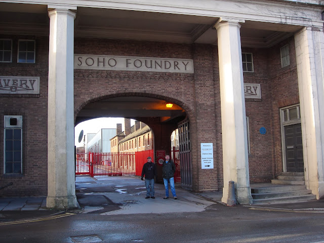
8.
Soho Foundry,
52°29'50.46", -1°56'50.94" Stand beneath the imposing gateway of the
Soho Foundry, opposite its eponymous pub where the tour can end with a drink and snack. This place is a prime target on the 1940s German air reconnaissance
maps - some of them which we saw in the
Avery Historical Museum entered below this gateway – the centre of an industrial hive.
![]() |
Black Patch Park is closely NW of the 3 parallel roads - Wills, Markby and Preston -
at the lower right hand corner of the 1940s Luftwaffe reconnaissance photo |
It is also where our tour might continue - exploring the remains of the
Soho Foundry and, still standing and part-used, the 19th century houses, first to be lit by gas.
![]() |
| Andrew and Phil |